

Quick answer
The Kjeragbolten hike is free: entrance costs 0 NOK, with mandatory paid parking at the trailhead of 300 NOK per vehicle. The trail begins at Øygardstøl, 4127 Lysebotn, and is open around the clock, though access is realistically seasonal — snow, fog and ice on the chain-assisted sections close the route in practice long before any gate does.
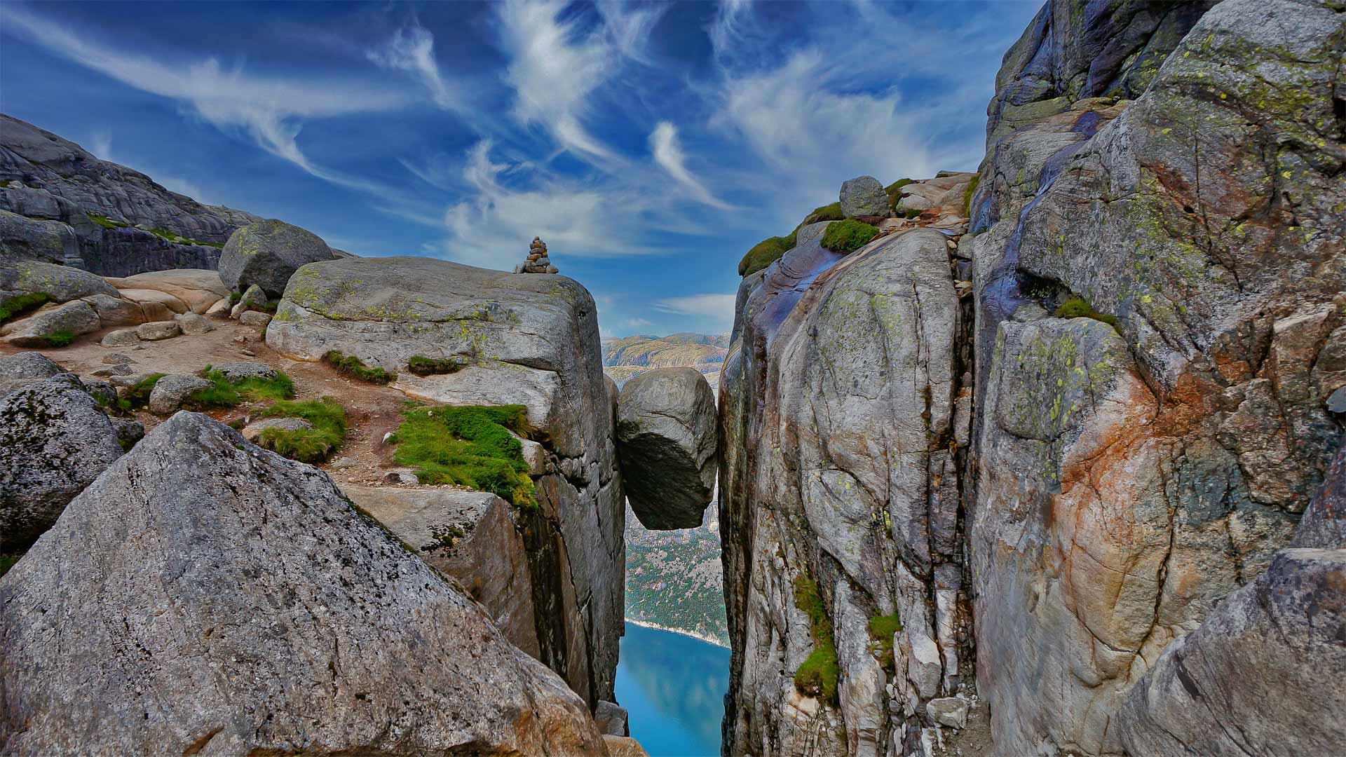
Kjeragbolten is not a placed monument. The boulder is a glacial erratic, jammed into a fissure at the end of the last ice age and left suspended roughly 984 metres above Lysefjorden, untouched by engineering. Nothing anchors it. That single geological accident is what draws walkers up the Kjerag plateau from Øygardstøl each season, and it explains why the kjeragbolten hike is measured less in kilometres than in the three steep ascents and two descents that separate the car park from the stone. What the reader is actually dealing with is a mountain route, not a viewpoint stroll. The path climbs Stordalen, then crosses bare granite slabs polished smooth by ice and weather, with fixed chains bolted into the rock on the steepest pitches. Cairns and painted T-markers carry the line where the granite gives no natural path. In cloud, those markers become the only navigation available. Norwegian sources call the route Kjeragbolten-turen, and the local framing matters: this is Norwegian mountain terrain in Rogaland, subject to fast weather changes rolling in off the fjord, and the plateau holds snow well into early summer. The Lysefjord landmarks nearby — Preikestolen, Flørli, the Lysevegen road — share the same volatility. The practical consequence is that a kjeragbolten hike guide is chiefly a guide to conditions. Access itself is unrestricted and unticketed; the constraint is daylight, weather and the state of the rock underfoot. Wet granite is genuinely slick, and the chains are handholds rather than safety systems. Anyone uncertain about exposure should know in advance that stepping onto the boulder is optional — the plateau viewpoint delivers the fjord and the drop without the crossing, and a large share of walkers stop there by choice. Use this page as the frame, then work through the dedicated sections below. They cover the weekly opening pattern, what parking costs, how to reach Øygardstøl by road or fjord, how long to allow on the mountain, and what to carry. Between them they answer the operational questions; what belongs here is the shape of the day and the honest measure of the terrain that produced this Norwegian landmark in the first place.
“Nothing anchors the boulder — it was wedged there by retreating ice and has stayed put ever since.”
Optimal Seasonal and Daily Timing for the Kjeragbolten Hike
The hiking season for Kjerag is restricted by snow conditions, typically spanning from June through September. Arriving during this window requires careful daily planning to manage trail congestion.
June–August
High traffic volumeTemperatures 10°C to 18°C. Frequent summer rain showers.
The most accessible months for hiking with stable trail conditions.
September
Moderate traffic volumeTemperatures 5°C to 12°C. Increased wind risk.
A quieter period as temperatures drop and autumn weather begins.
Weekday mornings
Low trail density—
Early arrival within the 00:00–08:00 best arrival window is necessary to avoid crowds at the boulder.
Verdict: The best time to hike is on a weekday morning during July or August, specifically arriving between 00:00 and 08:00 to minimize exposure to peak trail congestion.
Entrance Fees and Mandatory Parking Costs for the Kjeragbolten Hike
Access to the Kjeragbolten hike is provided free of charge to the public. Visitors are only required to pay for parking at the trailhead.
A typical adult pays 0 NOK for entrance, with the only mandatory cost being the 300 NOK parking fee per vehicle.
Directions and Transportation to the Kjeragbolten Hike Trailhead
The trailhead for the Kjeragbolten hike is located at Øygardstøl, situated above the village of Lysebotn in Norway. Access is primarily achieved by driving via regional mountain roads leading to the Lysefjord area.
Fv500 to Øygardstøl, 4127 Lysebotn
Summer shuttle bus service to Øygardstøl
Tourist ferry to Lysebotn, then taxi or shuttle to trailhead
Planning Your Kjeragbolten Hike Visit and Duration
This plan suits reasonably fit walkers tackling the Kjeragbolten hike as a single day trip from Øygardstøl, with no overnight stay involved. Budget 6 to 10 hours car-to-car for the roughly 12 km round trip, including photo stops at the boulder.
Trailhead at Øygardstøl
Set off from the Øygardstøl trailhead at the Kjerag car park, where the marked route begins. Read the trail board and check the weather before committing to the first ascent.
First chain ascent
Climb the first of three steep rock sections, using the fixed chains for balance on the smooth granite. Most walkers need 45 to 90 minutes for this stretch alone.
Second and third climbs
Cross the two shallow valleys between the ridges and tackle the remaining chain-assisted ascents and descents. Pace drops noticeably here, so allow extra time if the rock is wet.
Arrival at Kjeragbolten
Reach the plateau above Lysefjorden and the boulder wedged in the crevice. Walking time one way ranges from 2.5 hours for fast hikers to 4 hours at a steady pace.
Photo queue at boulder
Expect to wait for your turn at the boulder, from a few minutes on quiet days to 30 to 60 minutes when several groups converge. Use the wait to eat and take in the fjord view from the surrounding cliff edge.
Return leg to trailhead
Retrace the same route back over the three ridges, which takes roughly as long as the outbound walk and often longer on tired legs. The final descent to Øygardstøl is steep, so keep energy in reserve.
Back at the car park
Plan to finish with daylight to spare rather than pushing the return into dusk. The official site kjerag.info and +47 40306865 carry current trail status if conditions look uncertain.
Essential Preparation Checklist for the Kjeragbolten Hike
The Kjeragbolten route climbs and drops across three steep ridges on exposed granite, so preparation centres on footwear, layers, water and a realistic read of the weather.
-
Check the mountain forecast before committing — Wet granite and low cloud turn the chain sections dangerous.
-
Wear stiff, broken-in hiking boots — Ankle support matters on wet slab and loose scree descents.
-
Pack windproof and waterproof outer layers — Conditions at 1,000 m shift fast even on clear mornings.
-
Carry at least two litres of water — There are no refill points or services along the trail.
-
Bring gloves for the chain sections — Steel chains get cold, wet and hard to grip bare-handed.
-
Add a headlamp and spare batteries — Early starts and slower descents can leave you finishing in low light.
-
Save the emergency number +47 40306865 — Phone signal is patchy, so know your contact before you set off.
-
Skip the boulder step if unsure — Standing on Kjeragbolten is optional and the drop is unforgiving.
Official Opening Hours for the Kjeragbolten Hike Area
The Kjeragbolten hiking area is accessible to visitors daily throughout the week.
| Monday | 00:00–23:59 | |
|---|---|---|
| Tuesday | 00:00–23:59 | |
| Wednesday | 00:00–23:59 | |
| Thursday | 00:00–23:59 | |
| Friday | 00:00–23:59 | |
| Saturday | 00:00–23:59 | |
| Sunday | 00:00–23:59 |
The hiking trail and area are subject to seasonal conditions, particularly during winter months when snow and ice may impact accessibility.
Check availability
Frequently asked questions about kjeragbolten hike
Everything you need to know about kjeragbolten hike